

| | |
| Archaeological Fieldwork in 2006 (1) |
by Sören Stark, Seminar for Oriental Archaeology and Art History[1] Part 1 (go to Part 2)
The field season 2006 was focused on the Argly valley system which is located in the central section of the prospection area (fig. 1). Fieldwork took place from July 10th to August 25th. The joint Tadjik-German team consisted of U. Eshankulov, N. Rahimov, M. Gütte, A. Puk, and S. Stark.
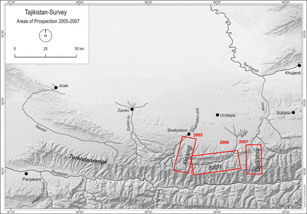
Figure 1: Areas of prospections 2005-2007
With an east-west-extension of ca. 50 km the Argly system is the most most extensive of the valley systems under prospection (fig. 2). It is made up by two branches of a main valley (Argly branch and Uguk-sai branch) and 18 major tributary valleys. The two main branches join about 4-5 km to the north-east of the kishlak Ovchi. After the confluence of both sais the river is generally called Basmanda-sai.
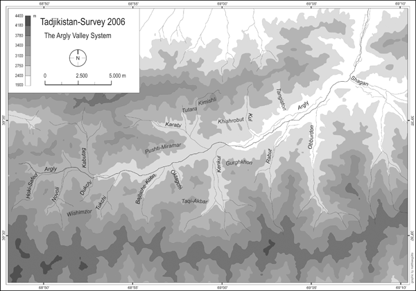
Figure 2: The Argly system with major tributaries
In contrast to the neighbouring Aktangi system the Argly valley is comparatively dry (fig. 3). Nevertheless, the upper parts of the valley system, above ca. 2800 m, still offer excellent pasture grounds in the period from June to September.

Figure 3: View from the ridge of the Turkestan range into the Novoli valley/upper section of the Argly system
Today the upper part of the valley system is completely deployed of permant settlements, only a handfull of seasonal hamlets and single farmsteads can be observed. Apart from marginal rainfall farming (lalmî) in the bottom of the valleys up to 2900 m (with crops such as barley, oat and rye) transhumant stockbreeding is clearly prevailing in the upper sections of the valley system (fig. 4).
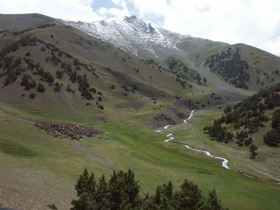
Figure 4: Summer pastures in the upper Hoki Safed valley
Below approximately the 2600 m elevation line the valley becomes substantially broader and changes its appearance: Intensive irrigation farming is prevailing, which sustaines the two medium sized kishlaks of Ovchi and Uguk (fig. 5).
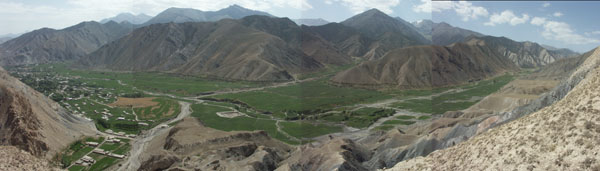
Figure 5: Lower Argly valley around Ovchi
Only the area of Ovchi and Uguk, that is the lower sections of the Argly system, have been subject to archaeological and ethnographical investigations in the past. Publications mention an early-mediaeval fortress near Ovchi (Qal'a-i-Mugh),[2] a small tepa in the south-western margins of Ovchi,[3] a mediaeval stone column from the mazar of Hodja Abdullo Ansori in Uguk[4] and traces of irrigation work (aryks and karezes).[5] In contrast to that, the upper parts of the valley system have never before been subject to systematic investigations.
Our field work was focused on surface prospections. Only exceptionally small test excavations were carried out. According to the ecological dichotomy of the valley system in an upper part (main valley and tributaries of the above the 2500 m elevation line; tributaries of the Uguk branch) and a lower part (main valley below the 2500 elevation line and main valley of the Uguk branch) the archaeological records from the two parts of the valley system differ substantially from each other and, therefore, will be presented separately.
2.1 The upper part of the Argly system
Archaeological records from the upper part of the Argly system constitute the following groups of material:
A. Barrows
In most of the tributary valleys above the 2500 m elevation line we were able to register at least 117 tumuli built from rubble (fig. 6). In all likelyhood they represent barrows (see also the results of test excavations below). It has to be noted that this number includes only larger barrows with diameters ranging from 3 to 28 m. The total number of burial mounts is substantially higher as smaller tumuli were difficult to trace individually and were, therefore, recorded only as "cemeteries". These new data clearly invalidate the older assertion that there are no substantial barrow grounds in Ustrushana.
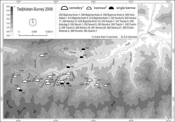
Figure 6: Distribution of barrows in the upper Argly Valley system
Barrow sites are mainly located in the southern tributaries. A distinct maximum was recorded in the Duktchi valley (site Duktchi-1) with about 44 clearly discernable barrows of diameters ranging from 3 to 28 m (the artifical character of another 20 mounts can not be definitely established). Considerable accumulations of medium sized barrows were also registered in the two neighbouring tributaries with at least 12 barrows in the Novoli valley (sites Novoli-3-5) and 18 barrows in the Tuktchi valley (sites Tuktchi-1-3). In addition, groups of 2 or 3 barrows are distributed over larger areas in other tributary valleys (see distribution map in Figure 6). In addition to surface prospections 4 barrows of small and medium size at 3 different spots (Tuktchi-3a, Novoli-3 and Novoli-4) were excavated. Our test excavations have yielded the following results:
a) Barrow Tukchi-3a/1 (fig. 7)
Below a flat rubble tumulus (diameter ca. 6,50 m) a construction of an outer and an inner ovale of stone boulders and rubble can be traced. Both ovals are oriented in NW-SE axis; the outer oval measures NW-SE 3,60 m and 2,70 m SW-NE), the inner oval 2,80 m resp. 1,60 m (all measures respresent inside dimensions). The space between both ovals is filled with rubble. The inner oval represents the grave chamber in form of a flat pit (ca. 20 cm below ground level).
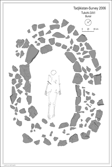
Figure 7: Barrow Tukchi-3a/1
The barrow yielded a single enterrement of unspecified gender which was situated in dorsal position oriented in SE-NW axis, with head pointing north-westwards. The only grave good which could be traced was a 17 cm long fragment of a slightly bent blade from an iron knife situated above the right humerus of the corpse.
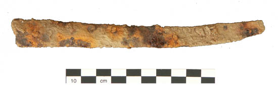
Figure 8: Fragment of an iron knife from barrow Tukchi-3a/1
b) Barrow Tuktchi-3a/2 (fig. 9)
The tumulus is made of a flat rubble mound (diameter 7-8,75 m). The grave chamber is situated almost in the middle of the tumulus and forms a rectagular stone cist, made of stone boulders or upright stone slaps. It is oriented in NE-SW axis (inside dimensions ca. 2,45 x 1,02 m). It was covered by flat stone slaps and is set about 50 cm below ground level.
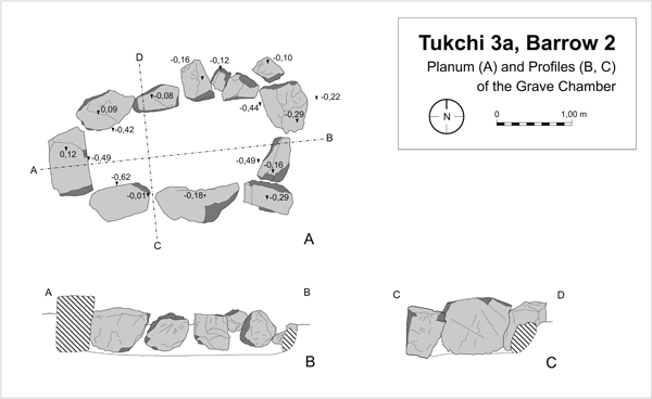
Figure 9: Barrow Tuktchi-3a/2
As the grave chamber contained neither any traces of an enterrement nor of grave goods we have reason to suppose the barrow to be a cenotaph burial. Few and highly fragmented sherds of hand-made pottery have been traced in the filling of the mound together with animal bones (sheep) and fire place traces.
c) Barrow Novoli-4
The superstructure of the tumulus resembles those of Tuktchi-3a (diameter ca. 7 m).
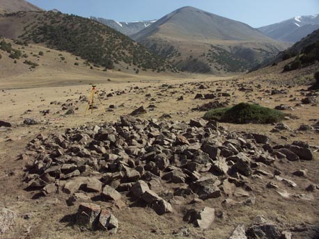
Figure 10: Tumulus of the Barrow Novoli-4 (after cleaning)
The grave chamber in form of a roughly rectangular stone cist, made of stone boulders or upright stone slaps, is oriented roughly in E-W axis. The chamber was originally covered by flat stone slaps which were partially collapsed into the cist. Due to very humid ground conditions the burial was badly preserved and difficult to trace. Still, traces of the cranium and a lower leg suggest a dorsal position oriented in E-W axis, with head pointing westwards. Apart from that, very few traces of an oblong iron object were traced on the left side of the enterrement, near to where the hip must originally have been situated.
d) Barrow Novoli-3
The flat rubble tumulus measures about 22,50 m in diameter. The burial was evidently plundered in Antiquity. The damage caused by the grave robbers made it impossible to trace the actual form of the grave chamber with certainty. Only the eastern part of the burial was left relatively untouched. There, bones from the lower legs upwards of one individual were preserved in anatomical order. Apart from that, parts of the cranium and of a lower leg of at least one more individual were recorded in the disturbed part of the grave chamber. The undisturbed parts of the corps might suggest supine position oriented roughly in E-W axis with head pointing westwards, thus similar to the three other burials from the upper Argly valley system excavated so far. Apart from human remains the filling of the grave chamber contained two very fragmented pottery sherds (base fragments), one of them re-used as a spindle whorl, the other one containing a potter's mark. Both fragments are hand made but it is difficult to chronologically specify them any further (a 5-6th century date might carryfully be suggested for at least the base fragment with the potter's mark). Furthermore it remains unclear if these fragments are part of the original burials or entered the filling later, during or after the robbery.
On the base of these data alone it is highly problematic to propose an exact dating for the barrows from the upper parts of the Argly system. There are certain features in grave construction and burial rite which have parallels in a rather broad chronological horizont - from late Bronze Age burials in western Ferghana (Kairakkum variant of Steppe bronze), certain burial types from cemetries of the Eilatan-Aktam-culture from south-eastern Ferghana to certain types of Kurum-burials mainly dating from the first century BC to the 6th/7th century CE. Regarding grave construction, these parallels pertain to flat grave pits of rectangular or oval layout, lined by small boulders or stones slaps, sometimes forming actual stone cists and frequently covered by flat stone slaps, sometimes overlapping each other, thus suggesting a kind of vault. Regarding burial rites parallels pertain to dorsal position, armes streched along the body, head pointing westwards, traces of ash and pottery sherds in the filling of the mounds and the coexistence of individual and collective burials. Unfortunately, the finding of only one fragment of an iron knife from barrow Tukchi 3a/1 and of some very fragmented sherds from Tukchi 3a/2 (which at least seem to be part of the original burial) do not allow a further specification in date than "early Iron Age to late Antiquity/early Middle Ages".
B. Petroglyphs
The discovery of petroglyphs in the course of our fieldwork in 2006 revealed a complex of archaeological material formerly unknown in Ustrushana. Interestingly, they only appear in the upper valley of the Novoli-sai which is one of the uppermost southern tributaries of the Argly (labelled as site "Novoli-2"). Here, we recorded a total of 63 stone boulders of different dimension with rock drawings.
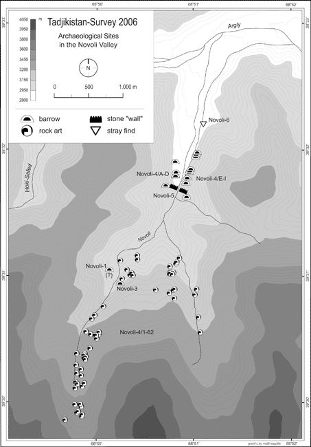
Figure 11: Archaelogical sites from the Novoli valley
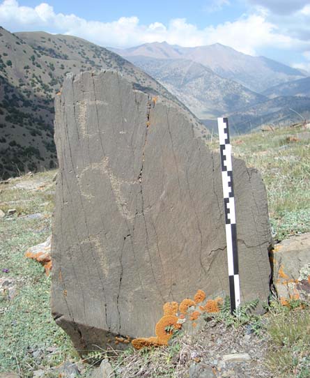
Figure 12: Stone boulder with petroglyphs from the Novoli valley
In terms of technique these rock drawings are fairly homogeneous - most of them are punched in darkish stone patina; only rarely drawings are craved into the patina with some spiky instrument. The dominating motif of the rock drawings from Novoli is the ibex (capra aegagrus), either as a single figure or as part of larger, multi-figured scenes (fig. 12).
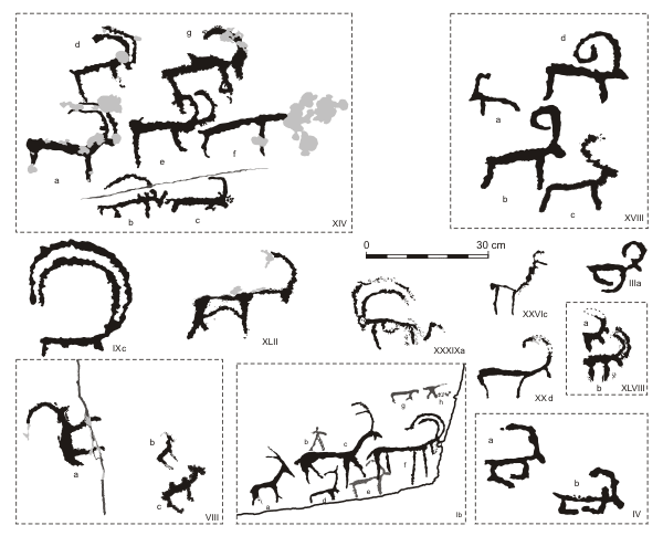
Figure 13: Sample of rock drawings from Novoli-2
Within this group a whole range of stylistic variants is evident. The only other animal species which can be identified with certainty in the rock drawings from Novoli is the Bactrian camel (camelus bactrianus; cf. Fig. 12/VIIIc). However, some animal depictions might represent dogs, in two cases horns are styled like antlers - so these representations might be interpreted as deers or the like (fig. 12/XVIIIc and XXVIc). In addition, in one case (fig. 12/XXXIXa) an ibex is depicted with a very uncharacteristic long tail (similar to the one of a cat). Consequently, one might speculate if this drawing might represent rather a fantastic creature than an ordinary ibex. Depictions of human or human-like characters occur only very rarely in the petroglyphs from Novoli.
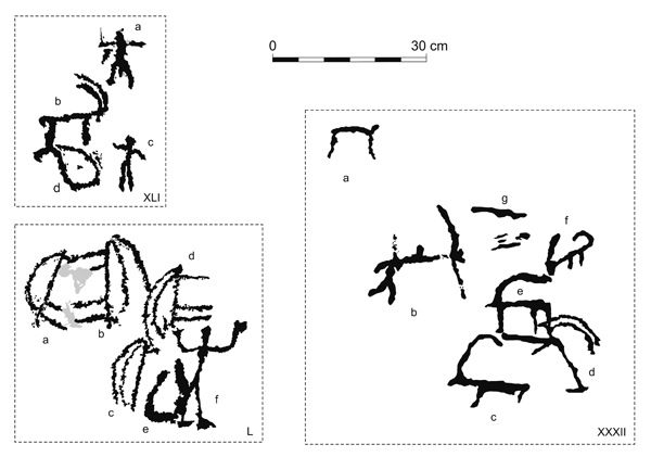
Figure 14: Sample of depictions of human figures from Novoli-2
A human figure can be found in a hunting scene (fig. 13/XXXIIb). But much more interesting is the representation of a human-shaped figure in a scene of unknown meaning (fig. 13/L): A human or human-like being, facing right is shown with raised arms, thus resembling the posture of an adorant; behind this figure (and partially merged with him) we find the depiction of an object in the form of an upright-standing oval. It is drawn in very broad contours and seems to be open towards its upper side. Behind this object there is the (incomplete) depiction of an upright standing ibex. Another upright standing ibex is given right above the human figure. Finally, two more upright standing ibexes are depicted to the left with their legs facing respectively merging into each other thus resulting in a heraldic motif. Interestingly, the exact findspot of the boulder containing this scene is located just a few meters beside the source of the Novoli-sai - a fact which might well have some relation to the meaning of this enigmatic scene. Finally, a group of motifs range from unanimated objects, such as the depiction of a chariot (fig. 14/XIXa), to various kinds of signs and symbols, some of them possibly tamghas (fig. 14).
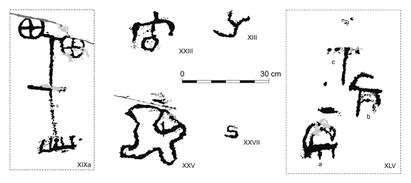
Figure 15: Sample of depictions of unanimated objects from Novoli-2
Regarding the date of the new rock art complex from Novoli we are faced with the usual problems of dating petroglyphs. However, at least the above mentioned depiction of an chariot (fig. 14/XIXa) can be securely dated to the late Bronze Age, when this motif was widely distributed in the rock art of Central Asia. At the same time stylistic features of other drawings - such as angled legs - are reminiscent of the early Iron Age animal style (fig. 12/IIIa, IV, XXd, XLVIII). It is of little surprise that the new rock art complex from Highland Ustrushana offers - both in style and motif - plenty of parallels to the neighbouring rock art complexes in Matcha (upper Zarafshan), the Mogultau and in the Kurama range (western Ferghana/Ilak). As mentioned above, petroglyphs seem to be located only in the upper section of the Novoli-say valley (fig. 11). Possibly, this comparably remote high mountain valley was at some time considered as a "sanctuary in the open". This idea is further strengthened by traces of a "wall" constructed of upright set stone slaps and rubble which runs over the entire width of the lower Novoli valley (cf. map in fig. 11). Although it is impossible to give an exact date for this wall it has to be emphasized that the whole complex of petroglyphs is situated beyond this "wall" towards the mountains. Therefore, it might be suggested that this line (symbolically?) refers to a "sacred precinct" in the higher parts of the valley.